
Walk a Watertown Street
A street directory search works best as a chain, not as a single claim about who lives at an address. Watertown's assessor identifies the parcel and the displayed owner. The GIS viewer supplies map context. The Town Clerk's land index links names to recorded instruments. A voter response or a historical directory can add a dated personal connection, but neither turns an owner list into a household roster. Keep the source date and record role beside every name.
- Enter the street number, street name, and unit in the Watertown assessor search. Open the card and copy its Unique ID and MBL, the map-block-lot parcel key.
- Open the Town GIS viewer and select the parcel. Check road, water, common land, and nearby parcel shapes without treating the display as a legal survey.
- Use the card's owner and volume/page clues in the Town Clerk's IQS index. Try alternate spellings when a name returns no match.
- Use Connecticut's exact voter lookup only when you already know the person's town, name, and full birth date. It is not a by-street roster.
- For an older household, ask the library or History Museum about the proper regional directory year, then compare the printed entry with census and newspaper evidence.
The sequence keeps ownership, residence, and mailing data apart. That distinction matters on vacant land, condominiums, and parcels whose owner receives mail outside Watertown.
Watertown Street Search Fields
The Watertown Property Search is the strongest first stop for a modern address. Location number, street name, and unit can be used apart or together. An owner surname, MBL, Unique ID, property-use choice, or condominium name can narrow a large set. Results expose the address, displayed name, parcel keys, use, acreage, zone, building count, and condominium complex.
| Field | How to use it | What it prevents |
|---|---|---|
| Number, Name, Unit | Build the physical address from separate fields | Mixing a unit with the street number |
| Owner Name | Try the last name alone first | Missing initials or spelling variants |
| MBL or Unique ID | Carry the stable parcel key to later checks | Confusing similar street labels |
| Property Use | Select Residential or the relevant use | Overly broad results |
| Condo Complex | Pair the complex with unit data | Treating common land as a home |
The live assessor screen shows why a good street directory keeps fields separate. See the official Watertown assessor form before using the controls shown below.
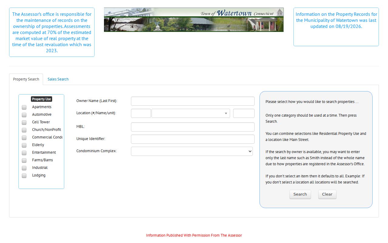
The captured form provides both Property Search and Sales Search tabs. The address workflow belongs in Property Search; sales filters answer a different question.
Map Watertown Streets Carefully
Watertown's ArcGIS parcel viewer helps catch side-road and behind-lot parcels that a straight street list can miss. Search an address, choose the result, and click its polygon. Then inspect each polygon that touches it. Roads, water, condominium common parcels, and gaps can change which lots count as adjacent.
Map lines are for reference. They can look offset at a given zoom and are not a legal survey. Water, Oakville, Westgate, and Northern utility service zones also are not ZIP, voting, or deed boundaries. Use GIS to see context, then retain the assessor's MBL or Unique ID for the exact parcel.
Note: A parcel map helps define the block, but the Town Clerk's recorded maps and deeds control a legal ownership question.
Watertown Street Directory Sources
Each source has its own key and limit. The coverage table shows which Watertown record accepts an address, which needs a name, and which offers only historical context. Online access is only one channel. The Assessor, Town Clerk, Registrar, library, and museum also handle counter, phone, mail, or reference requests.
| Address source | Watertown keeper | Useful street evidence | Access route |
|---|---|---|---|
| Parcel card | Watertown Assessor | Situs, displayed owner, mailing data, use, card history | Free portal, office, or phone |
| GIS parcel map | Town engineering map | Parcel shape, map setting, adjacent parcels | Free viewer; office help for layer questions |
| Land records | Watertown Town Clerk | Parties, instrument, date, volume/page, image route | IQS index from 1996; counter for older books |
| Voter record | Connecticut SOTS and Watertown Registrars | Exact-person registration and polling response | Exact online lookup; registrar correction route |
| Permit file | Building or Planning and Zoning | Public permit or application material tied to a structure | Department request; public index coverage not verified |
| Historical directory | Library, History Museum, archives | Dated name, address, business, or household clue | Catalog, licensed database, volunteer lookup, or visit |
No one table proves a household. A parcel key ties the assessor view to a map, while an owner name and volume/page bridge to deeds. A permit may explain the building, and a dated directory may identify a past association. For the modern address-first method, stay with this street directory; the Watertown city directory collections cover the historical shelf in depth.
Follow Watertown Deeds by Name
The Watertown IQS land-record index does not make the street address its main key. Begin with the current card's displayed owner or volume/page. In Quick Search, a Search Term can be a grantor or grantee name, subdivision, document type, or document number. A grantor transfers an interest; a grantee receives it. Date-range controls and Index Only or Index & Full Text modes help narrow the result.
Online records begin January 1, 1996 at Volume 802, page 45. Older books and maps require the Town Clerk counter. Index images are reference copies, and free downloads may carry an Unofficial Copy watermark. IQS lists a $2-per-page image/copy route. Staff will help locate records, but they do not run title searches or give an ownership opinion.
The official deed-search screen shows the actual query controls captured here.
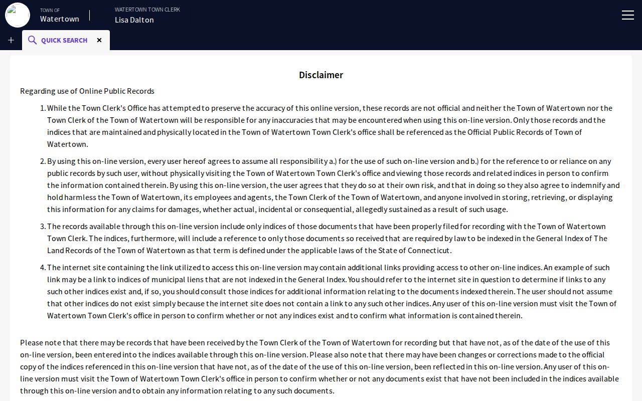
The image makes the name-first bridge clear. Copy the exact index spelling, book/page, date, and instrument type before moving backward to the prior owner.
Four Watertown Address Meanings
A Watertown address can be a parcel's physical location, an owner's mailing address, a voter's residence, or a USPS delivery label. The Loop Road sample makes the point: its parcel card has no street number and shows a Brookfield mailing address for a Watertown parcel. A ZIP-only or mailing-city query could miss it.
- Parcel
- A mapped piece of land identified by a local key such as MBL or Unique ID.
- Situs address
- The physical property location, which may differ from the owner's mailing address.
- Plat
- A recorded map showing lots, roads, or subdivision detail; it is checked with the Town Clerk.
- Criss-cross directory
- An address-first directory arranged by street and number instead of only by surname.
This four-part comparison belongs beside each address result. Record the source label and date before writing that a person owns, receives mail at, votes from, or once appeared at an address.
Voters Are Not Street Rosters
Connecticut's voter lookup asks for town, first name, last name, and full date of birth. That makes it useful for checking a person already known, not for listing everyone on a Watertown block. A parcel owner may vote elsewhere, and a voter can live at an address without owning it. Safe at Home can also protect an eligible participant's address.
Review the official Connecticut voter form shown below before treating its response as one layer of confirmation.
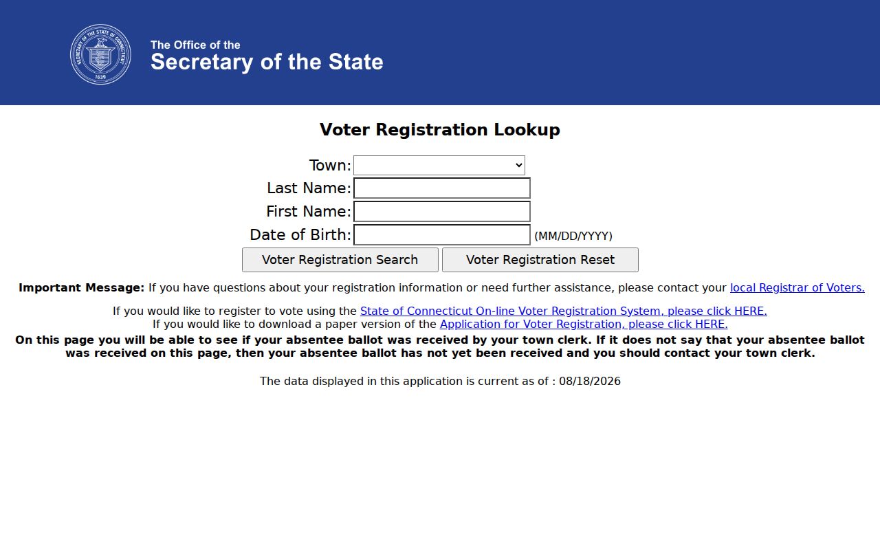
The required full birth date reinforces the limit: this is an exact-person check, not a public by-address browsing tool. The Watertown Registrars handle corrections and local election questions by phone and during posted public hours.
Older Watertown Street Residents
Verified regional directories include Watertown in 1910, 1929 through 1932, and 1962. Digifind adds local newspapers, scrapbooks, and yearbooks with collection-specific runs from 1881 through 2014. Use a printed street or household entry as dated evidence, then compare it with census, deed, obituary, or newspaper material.
No public Watertown page confirmed a local criss-cross run, Sanborn map set, or formal street-renumbering history. Ask the library, History Museum, Town Clerk, Assessor, or planning staff for the exact title, year, and old map before calling a volume reverse-address material. This street directory should preserve an old spelling until the original page and parcel context agree.
Note: Missing online material is a reason to use a reference desk or counter, not proof that the historical record never existed.
Watertown Streets Cross Postal Labels
Oakville is part of Watertown, but it uses the distinct postal label and ZIP 06779. The primary Watertown postal place uses 06795. That is a useful search quirk, not proof of a municipal split. Keep Watertown as the legal town while testing both postal labels in old directories, mail records, and local news.
The USPS Watertown location record provides the verified 06795 post-office reference shown here.
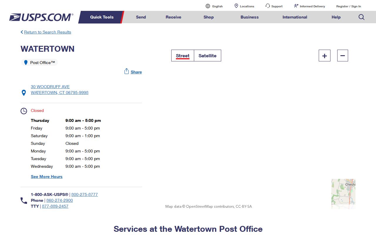
The USPS page establishes a postal location, not a street-by-street ZIP boundary. For one delivery address, validate through USPS; for a parcel, return to the assessor and GIS. The assessor has no ZIP field, so a mailing filter cannot replace the physical-address search.
Watertown Street Directory Limits
A Watertown street directory cannot provide a complete household list. The assessor names an owner of record, not each resident. GIS maps parcels rather than people. A deed records an instrument, while a historical entry captures only one publication date. Voter access has exact-search and privacy limits. Building and planning pages did not expose a verified complete public permit index, so the department request is the fallback when a card's permit line needs context.
Lawful use. Use Watertown address records only for lawful personal research. Never use a name, address, map, or directory entry to stalk, harass, intimidate, or harm anyone.
If accuracy matters, ask the record keeper for the current record or a certified copy. The Town Clerk, Assessor, Registrars, library, and museum each answer a different part of the address trail.